The Smplrspace platform
A single platform built around space, bringing together the capabilities and services that teams use to visualize, understand, and act on real estate data.

Interactive 2D & 3D floor plans
Turn static floor plan images into clean, interactive digital spaces that teams can navigate, share, and reuse across workflows.
Turn static plans into lightweight, digital 2D and 3D spaces
Navigate smoothly across units, floors, and buildings
Share access to spaces across teams and workflows

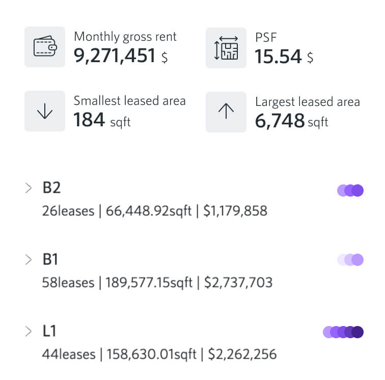
Reporting & business intelligence
Use spatial reporting to turn any real estate data into clear, shared views that support faster, better-aligned decisions accross your organization.
Visualize any real estate data directly on buildings and floors
Supports myriad of use cases and executive decision-making
Align teams using shared, spatial reporting views


Integrate & embed Smplrspace
Embed interactive building and portfolio views into products and workflows, enabling rich, two-way interaction with real estate data.
Embed building and portfolio views into software products
Capture user interactions and trigger workflows or actions
Integrate with your existing tools and processes


Real estate portfolio intelligence
Work with portfolios in full real-world context, bringing indoor building detail together with outdoor and geographic insight.
Create flexible portfolio views based on any criteria
Explore indoor spaces alongside geographic context
Keep full spatial navigation across buildings and portfolios

Services accelerating setup
Our services were designed to help teams move faster and get more value from Smplrspace, without taking on extra operational work.
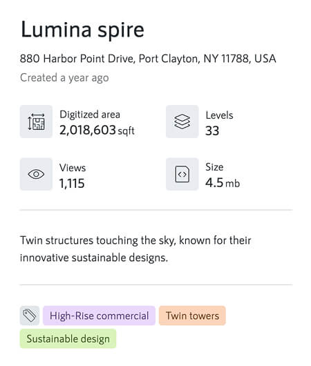
Floor plans digitization
Our digitization services focus on clarity and consistency, producing lightweight, clutter-free digital spaces that are easy to navigate, reuse, and scale.
Spaces digitized in days, handled by experienced digitization experts
Transparent pricing based on square footage and service complexity
Only one measured dimension is needed to accurately size the entire space.
Data mapping
Our team assigns IDs to entities like sensors and furniture, linking database items to their exact location so they can be used across reports and external systems.
Precise mapping of spatial entities to unique, stable identifiers
Consistent data linking across Smplrspace reports and software products
Handled by our digitization experts to ensure accuracy at scale
A practical path from pilot to portfolio scale
Smplrspace lets owners and operators prove value quickly, then grow into operational and portfolio-wide use without reworking data, tools, or processes.
Pilot first
Teams usually start with a focused pilot, digitizing a limited set of spaces and a small number of use cases to quickly validate value and align stakeholders.
Scale into operations
Once value is proven, Smplrspace is integrated into the systems and workflows already used across the organization to support day-to-day operations.
Expand across portfolios
As adoption grows, usage spreads across portfolios and geographies, supporting more assets, teams, and strategic decisions.
From fast prototyping to production-ready integrations
Smplrspace allows software teams to experiment, ship, and scale spatial functionality at their own pace, with support available as spatial content becomes core to the product.
Quickly prototype
Start integrating Smplrspace for free with up to three spaces, making it easy to test ideas and build early prototypes.
Move into production
Integrations are typically fast to implement, with documentation designed to support even low-code teams, allowing products to ship when ready.
Scale with demand
As demand for digitized spaces grows within your product, you can rely on Smplrspace’s fast digitization and data mapping services to ensure operational efficiency.